


Blaeu, Ducatus Holsatiae Nova Tabula.
Ducatus Holsatiae Nova Tabula.
Original hand-coloured engraving. Amsterdam Blaeu, [1638]. Plate Size: 51.4 cm x 38 cm. Sheet Size: 56.5 cm x 47 cm. Original and rare map. In very good, clean condition. Minor tear to lower edge at center-fold. French text on reverse.
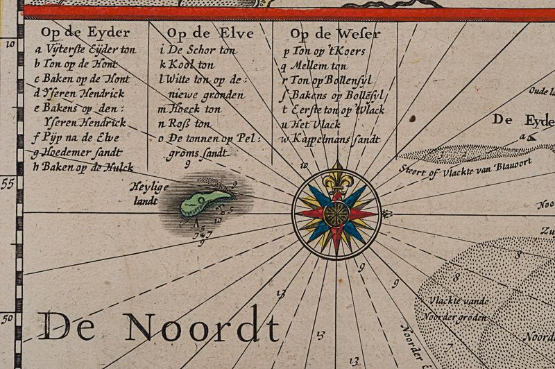
Beautiful and detailed map of the Duchy of Holstein, the northernmost territory of the Holy Roman Empire, from the mid-17th Century. To the north lies the Danish Duchy of Schleswig. In the south are Meklenburg and Lower Saxony. Fehmarn Island lies just off Holstein’s Baltic coastline. The strategically and commercially important great port cities of Hamburg, Kiel and Lubeck are all shown on the map. Holstein is crisscrossed with waterways: the Elbe river being the most prominent, and together with Trave, provided pathways for the region’s trade. The vessel depicted in the North Sea approaching the sandbars suggests the importance of trade to the region. Relief depicted pictorially.
Two inset box provide further detail of the specific locales. The inset box in the upper left shows the marshy coastal area around Dagebüll on the western coast. The depicted wierde/terp (artifical artificial dwelling mound) that were created in the marshy, low-lying reclaimed land to provide safe ground during storm surges, high tides and sea or river flooding. The inset box in the top right corner shows the area in and around Stapelholm.
Cartouches in the lower corners contain bar-scales and provenance details. Annotative text in the North Sea. Two compass roses lie on either side of Holstein.
Willem Janszoon Blaeu (1571-1638) was a Dutch cartographer, atlas maker and publisher. Along with his son Johannes Blaeu, Willem is considered one of the notable figures of the Netherlandish/Dutch school of cartography in its golden age (the 16th and 17th centuries). Blaeu set up his mapmaking and publishing business in Amsterdam, where he sold instruments and globes, published maps, and edited the works of intellectuals like Descartes and Hugo Grotius. In 1633 he was appointed map-maker of the Dutch East India Company. In 1635, he released his atlas, Theatrum Orbis Terrarum, sive, Atlas novus.
Willem died in 1638. He had two sons, Cornelis (1610-1648) and Johannes (1596-1673). Joan trained as a lawyer, but joined his father’s business rather than practice. After his father’s death, the brothers took over their father’s shop and Joan took on his work as hydrographer to the Dutch East India Company. Later in life, Joan would modify and greatly expand his father’s Atlas novus, eventually releasing his masterpiece, the Atlas maior, between 1662 and 1672. (Wikipedia)
- Keywords: 17th Century · Alte Landkarte – Holstein · Cartography · Catalogue No.5 – Maps of the World · Denmark · Europe · Germany · Holstein · Landkarten · Map · Original Engraving · Original Map · Original Maps · Rare Map – Germany · Rare Map Europe · Schleswig-Holstein · Vintage Map
- Inventory Number: 200050AG
EUR 475,--
We ship per DHL Express


Contact
Inanna Rare Books Ltd.
Woodley House
Castletownshend Road
P81 D262 Skibbereen, County Cork
Ireland
Phone: ++353 - (0) 87 - 102 5412
E-Mail: info@inannararebooks.com
Internet: https://www.inannararebooks.com
Online Bookshop specialized in rare
and secondhand books.
Newsletter and E-Catalogue Sign Up
Payment Options


© 2024 Inanna Rare Books Ltd. | Powered by HESCOM-Software

