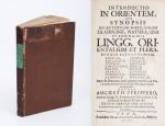
West Cork Rare BookfairINANNA MODERNWest Cork Reading Holidays
We ship per DHL Express

We ship per DHL Express

Complete Catalog (8613 items)

Parkman, Francis Parkman's Works - Frontenac Edition.

6060. Parkman, Francis.

Francis Parkman’s Works – Frontenac Edition. The collection includes: Volume I and II: “Pioneers of France in the New World” / Volume III and IV: “The Jesuits in North America” / Volume V: “LaSalle and the Discovery of the Great West” / Volume VI and VII: “The Old Regime in Canada” / Volume VIII: “Count Frontenac and New France under Louis the XIV” / Volume IX and X: “A Half Century of Conflict” / Volume XI, XII, XIII: “Montcalm and Wolfe” / Volume XIV and XV:″The Conspiracy of Pontiac and the Indian War after the Conquest of Canada” / Volume XVI: “The Oregon Trail, Sketches of Prairies and Rocky-Mountain Life” / Additional Volume [the so-called Volume XVII: “A Life of Francis Parkman” (by Charles Haight Farnham) //

17 Volumes [complete set of 16 Volumes plus the often missing Biography]. Boston, Little, Brown and Company, 1902 – 1904. Octavo. More than 6000 pages. Frontispiece with tissue-guard to each Volume. Photographic illustrations and occasionally maps within the text. Original Hardcover (blue publisher’s cloth with original spinelabels and as a special ephemera treat in each Volume are two spare spine-labels tipped into the rear [In case of rebinding or fading of the exisiting spine-labels]. Very good condition with only minor signs of external wear (some rubbing). From the library of Hans Christian Andersen – Translator Erik Haugaard, with Haugaard’s Exlibris to the pastedown of each Volume.

EUR 780,-- 

Show details   Add to cart

Daniel Paterson & Edward Mogg - Paterson's Roads [1831/1832 Edition (18th Edition) with 12 Maps]

6074. [Paterson, Daniel] Mogg, Edward.

Paterson’s Roads [1831/1832 Edition (18th Edition)] – Being an entirely original and accurate Description of all the direct and Principal Cross Roads in England and Wales, with part of the roads of Scotland. [Including an “Appendix to the Eighteenth Edition of Paterson’s Roads; being An Accurate Description of the Direct and Principal Cross roads communicating with the Improved Old Passage Ferry, across the River Severn, between Aust and Beachley, near Chepstow. Accompanied by a Map of the Banks of the Wye. To which are added, Course of the Chepstow Steam Packets; and An arranged Tour through Wales, with References to the pages in the Body of the Work, where connection with various lines of Road takes place.”]. The Eighteenth Edition. To which are added Topographical Sketches of the several Cities, Market Towns and remarkable Villages and descriptive accounts of the principal seats of the Nobility and Gentry, the Antiquities, Natural Curiosities and other Remarkable Objects throughout the Kingdom. The whole Remodelled, Augmented and Improved by the Addition of Numerous New Roads and New Admeasurements, and Arranged upon A Plan at once Novel, clear and intelligible, is deduced from the latest and best Authorities: Including a Table of the Heights of Mountains from the Grand Trigonometrical Survey of the Kingdom; Also a Table of the Population, From the Census of 1831; To which is annexed the Arrival and Departure of the Mail, together with the Rates of Postage and An Entirely New Set of Maps.

London, Printed for Longman, Rees, Orme, Brown, Green and Longman, 1831/1832. Octavo (15 cm x 21,5 cm). Fontispiece – Fold-out-Map, 715 pages plus 44 pages of an Appendix. With twelve (12) Maps, including the frontipiece-map and full-page maps throughout the publication. Hardcover / Private half-leather of the early 20th century with gilt lettering on the spine. Some of the maps with visible reapirs but complete. Very good condition with only minor signs of wear. This being the so-called “Best Edition”.

EUR 750,-- 

Show details   Add to cart

Payne, Universal Geography formed into a new and entire system

6098. Payne, John.

Volume I (of III) of the “Universal Geography” [Including Asia, Africa and Voyages of English Navigators] – formed into a new and entire system; describing Asia, Africa, Europe, and America; with their subdivisions of Empires, Kingdoms, States, and Republics: the extent, boundaries, and remarkable appearances of each country; cities, towns, and curiosities of Nature and Art. Also giving a general account of the fossil and vegetable productions of the Earth, and of every species of animal: The History of Man, in all Climates, Regions and Conditions; Customs, Manners, Laws, Governments and Religions: The State of Arts, Sciences, Commerce, Manufactures and Knowledge. Sketches of the Ancient and Modern History of each Nation and People to which is added, A Short View of Astronomy, as connected with Geography; of the Planetary System to which the Earth belongs; and of the Universe in General. With a set of Maps, drawn from the best Materials, every one of which is very neatly coloured; and a great Variety of Copper-Plates; descriptive of the most remarkable curiosities in the world. With an Appendix in two Parts, containing I. The History of the Voyages round the World, and toward the North and South Pole, which have been made since the year 1764 by English Navigators and II. A Digested and Geographical Account of the most considerable Islands and Countries which have been either discovered or explored during those Voyages, collected from every writer upon those subjects. Part I on the Appendix includes: 1. The First Voyage round the world, performed by Commodore Byron, in the Dolphin, accompanied by the Tamar Sloop / 2. Captain Wallis’s Voyage round the World, being the Second performed in the Dolphin / 3. Continuation of Captain Carteret’s Voyage round the World in the Swallow / 4. Lieutenant Cook’s Voyage round the World, in the Endeavour Bark (First Voyage, Second Voyage and Third Voyage including a stunning engraving of Cook, together with Portraits of inhabitants of the Sandwich Islands, Mangea and Ulietea) / The Appendix Part II contain a Geographical Account and Description of the Islands which have been lately discovered or visited in the South-Sea, proceeding from East to West (Easter Island / The Society Islands / The FRiendly Islands / The New Hebrides, Mallicolo and New Caledonia / New Zealand / New Holland / The Sandwich Islands //

First Edition. Dublin, Printed by Zachariah Jackson (Great Ship-Street), 1792. Quarto. XV, 894 pages with a list of subscribers and eight fantastic full-page copper engravings (NO MAPS in this Volume) / Frontispiece (The beautiful Frontispiece-plate is cleanly detached and now comes with this beautifully restored book framed): Plates included are: 1. Frontispiece: Vegetable Productions constituting important Articles of Commerce: Nutmeg Tree / Bohea Tea Plant or Thea Bohea / The Cotton Shrub / The Nutmeg enclosed in the Mace and Nutmeg Kernel / Flower of Tea / The Cotton Shrub – This plate is hand-coloured ! / 2. The Artificial Sphere (Globe) with the Solar System and Divisions of the Earth / 3. [Kamtschatka] – A Kamtscadale Travelling in Winter / An inside View of a Winter-Hut of the Kamtschadales / 4. Animals in the Southern Parts of Africa (The Rhinoceros Bicornis / The Buffalo / The Hippopotamus, called by the Hottentots the Seacow) / 5. The Country contiguous to the Cape of Good Hope – Hottentots and their Huts &c. &c. / 6. Portrait – Collection on one plate of Captain James Cook – Killed on the Island of Owhyhee – 14th of February 1779 (From a painting by Dance in the possession of Sir Joshua Banks) – other portraits on that page include A woman and a man of the Sandwich Islands / A Man of the Magea – Omai or Omia , a Native of Ulietea / 7. Portrait – Collection on one plate of: Poulaho – King of the Friendly Islands / A Man of van Diemen’s Land / A Woman from van Diemen’s Land / A Woman of Prince William’s Sound / A Man of Prince William’s Sound / 8. Portrait-Collection on one plate of: A woman of Otaheite Island (Tahiti) bringing a present / A Woman of Otaheite (Tahiti) dancing / An Otahetian (Tahiti) in the Dress of his Country / A New Zealand Warrior completely armed (Maori) // Hardcover / Professionally restored original 18th-century leather with original gilt ornament and new labels on spine. Binding rubbed but after the masterful restoration in very good condition. Some of the plates slightly loose but not detached. Very few minor wormhole damage to the last 250 pages. Rare with the plates ! From the library of Richard Meade, Ballymartle, with his original bookplate to the pastedown. One of the early accounts of english Navigation and Discovery.

EUR 1.200,-- 

Show details   Add to cart

Payne, A New and Complete System of Universal Geography; Describing Asia, Africa

6099. Payne, John / Hardie, James / Provenance I: Signature of J.J. Westervelt [Jacobus James Westervelt (1755 – 1826) – Schraalenberg and Provenance II: Charles Sydney Clark (1925) presented this set to Johnson Free Public Library at Hackensack, New Jersey].

A New and Complete System of Universal Geography [Complete with all 20 maps / illustrations] ; Describing Asia, Africa, Europe and America; with their Subdivisions of Republics, States, Empires and Kingdoms : The Extent, Boundaries and Remarkable Appearances of each Country; Cities, Towns and Curiosities of Nature and Art. Also giving a general account of The Fossil and Vegetable Productions [with hand-coloured plates] of the Earth. The History of Man, In all Climates, Regions and Conditions; Customs, Manners, Laws, Governments and Religions: The State of Arts, Sciences, Commerce, Manufactures and Knowledge. Sketches of the Ancient and Modern History of each Nation and People to the present time. To which is added, A View of Astronomy, As connected with Geography; Of the Planetary System to which the Earth belongs; And of the Universe in General. With a copious Index annexed to each Volume. Being a Large and Comprehensive Abridgement of Universal Geography. By John Payne. With additions, corrections and Improvements from the latest and best authors by James Hardie – Author of “The Principles of Latin Grammar”, “The American Remembrancer” and “Universal Tablet of Memory” &c. In Four Volumes.

First Abridged Edition. Volumes I [Asia] and II [Africa] (of IV). New York, Printed for and Sold by John Low, Book-Seller at The Shakespeare – Head, No.332 Water-Street, 1798 – 1799. Octavo – Edition. Pagination: Volume I [Asia]: Folded Frontispiece (Map of the World), XLVIII, 518 pages plus 10 unnumbered pages of an Index and one additional page with Directions for the Bookbinder for placing the maps and illustrations as well as Errata. Volume I includes all 10 Maps / Engravings as called for / Volume II [Africa]: Folded Frontispiece (Map of Africa), 578 pages plus 12 unnumbered pages of an Index plus one additional page with Directions for the Bookbinder for placing the maps and illustrations as well as Errata. Volume II includes all 10 Maps / Engravings as called for. Hardcover / Modern Library – Binding with the original 18th century – work bound in. Former library copy of Bergen County Historical Society (cancelled) and Johnson Free Public Library in Hackensack, New Jersey, with a very boring, modern library binding and library cards applied to the endpapers only, leaving the bookblock with text and maps and illustrations entirely untouched from any library-signs. Very good condition with some signs of external wear.

EUR 2.480,-- 

Show details   Add to cart

Page: 1 2 ... 119 120 121 122 123 124 125 ... 172 173
: