5739. Payne, John.
Volume I (of III) of the “Universal Geography” [Including Asia, Africa and Voyages of English Navigators] – formed into a new and entire system; describing Asia, Africa, Europe, and America; with their subdivisions of Empires, Kingdoms, States, and Republics: the extent, boundaries, and remarkable appearances of each country; cities, towns, and curiosities of Nature and Art. Also giving a general account of the fossil and vegetable productions of the Earth, and of every species of animal: The History of Man, in all Climates, Regions and Conditions; Customs, Manners, Laws, Governments and Religions: The State of Arts, Sciences, Commerce, Manufactures and Knowledge. Sketches of the Ancient and Modern History of each Nation and People to which is added, A Short View of Astronomy, as connected with Geography; of the Planetary System to which the Earth belongs; and of the Universe in General. With a set of Maps, drawn from the best Materials, every one of which is very neatly coloured; and a great Variety of Copper-Plates; descriptive of the most remarkable curiosities in the world. With an Appendix in two Parts, containing I. The History of the Voyages round the World, and toward the North and South Pole, which have been made since the year 1764 by English Navigators and II. A Digested and Geographical Account of the most considerable Islands and Countries which have been either discovered or explored during those Voyages, collected from every writer upon those subjects. Part I on the Appendix includes: 1. The First Voyage round the world, performed by Commodore Byron, in the Dolphin, accompanied by the Tamar Sloop / 2. Captain Wallis’s Voyage round the World, being the Second performed in the Dolphin / 3. Continuation of Captain Carteret’s Voyage round the World in the Swallow / 4. Lieutenant Cook’s Voyage round the World, in the Endeavour Bark (First Voyage, Second Voyage and Third Voyage including a stunning engraving of Cook, together with Portraits of inhabitants of the Sandwich Islands, Mangea and Ulietea) / The Appendix Part II contain a Geographical Account and Description of the Islands which have been lately discovered or visited in the South-Sea, proceeding from East to West (Easter Island / The Society Islands / The FRiendly Islands / The New Hebrides, Mallicolo and New Caledonia / New Zealand / New Holland / The Sandwich Islands //
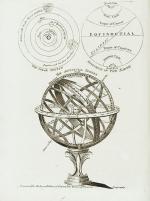
First Edition. Dublin, Printed by Zachariah Jackson (Great Ship-Street), 1792. Quarto. XV, 894 pages with a list of subscribers and eight fantastic full-page copper engravings (NO MAPS in this Volume) / Frontispiece (The beautiful Frontispiece-plate is cleanly detached and now comes with this beautifully restored book framed): Plates included are: 1. Frontispiece: Vegetable Productions constituting important Articles of Commerce: Nutmeg Tree / Bohea Tea Plant or Thea Bohea / The Cotton Shrub / The Nutmeg enclosed in the Mace and Nutmeg Kernel / Flower of Tea / The Cotton Shrub – This plate is hand-coloured ! / 2. The Artificial Sphere (Globe) with the Solar System and Divisions of the Earth / 3. [Kamtschatka] – A Kamtscadale Travelling in Winter / An inside View of a Winter-Hut of the Kamtschadales / 4. Animals in the Southern Parts of Africa (The Rhinoceros Bicornis / The Buffalo / The Hippopotamus, called by the Hottentots the Seacow) / 5. The Country contiguous to the Cape of Good Hope – Hottentots and their Huts &c. &c. / 6. Portrait – Collection on one plate of Captain James Cook – Killed on the Island of Owhyhee – 14th of February 1779 (From a painting by Dance in the possession of Sir Joshua Banks) – other portraits on that page include A woman and a man of the Sandwich Islands / A Man of the Magea – Omai or Omia , a Native of Ulietea / 7. Portrait – Collection on one plate of: Poulaho – King of the Friendly Islands / A Man of van Diemen’s Land / A Woman from van Diemen’s Land / A Woman of Prince William’s Sound / A Man of Prince William’s Sound / 8. Portrait-Collection on one plate of: A woman of Otaheite Island (Tahiti) bringing a present / A Woman of Otaheite (Tahiti) dancing / An Otahetian (Tahiti) in the Dress of his Country / A New Zealand Warrior completely armed (Maori) // Hardcover / Professionally restored original 18th-century leather with original gilt ornament and new labels on spine. Binding rubbed but after the masterful restoration in very good condition. Some of the plates slightly loose but not detached. Very few minor wormhole damage to the last 250 pages. Rare with the plates ! From the library of Richard Meade, Ballymartle, with his original bookplate to the pastedown. One of the early accounts of english Navigation and Discovery.






























![Parsons, Lone Star Living - Texas Homes and Ranches [Signed / Inscribed by PhotographerJack Parsons].](/images/thumbnails/32176AB.jpg)


![Boris Pasternak - Doktor Zhivago. [Rare Original Russian Edition]](/images/thumbnails/29201AB.jpg)

![Daniel Paterson & Edward Mogg - Paterson's Roads [1831/1832 Edition (18th Edition) with 12 Maps]](/images/thumbnails/31251AB.jpg)


![Patterson, The Harp and Irish Music [Article in Journal of the Ivernian Society Volume III - January - March]](/images/thumbnails/101157AB.jpg)
![[Pattison, Sister Dora - A Biography [of english nurse Dorothy W. Pattison].](/images/thumbnails/29221AB.jpg)
![[Paul de Man] Weinrich, Positionen der Negativität.](/images/thumbnails/29813AB.jpg)















![Klaus Stopp - The printed birth and baptismal certificates of the German Americans [Pennsylvania Germans]](/images/thumbnails/31173AB.jpg)