The Travels of Mirza Abu Taleb Khan in Asia, Africa, and Europe, during the years 1799, 1800, 1801, 1802, and 1803. Written by himself, in the Persian language. [With an Appendix: ‘Author’s Vindication of the Liberties of the Asiatic Women’]. Translated by Charles Stewart, Esq.
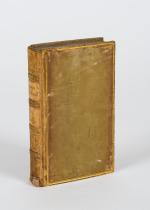
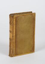
First and only Edition. Two Volumes (complete set). London, Longman, Hurst, Rees, and Orme, 1810. Octavo. Frontispice-Portrait with original tissue-guard, VIII, (8), 320, 418 pages. Hardcover / Beautifully restored bindings by english master binders in stunning modern half-morocco with the original spine-labels applied. Original endpapers and pastedowns with the original bookplates / Exlibris preserved. Excellent condition with some browing and ghosting to the pages, as usual with this set. Name of historical preowner Richard Meade in ink on titlepages. Rare in this very amazing restored condition.
EUR 1.000,--


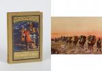
![[Himalaya / Darjeeling]. Collection of two (2) 19th century photographs of traditional tourist locations in Darjeeling](/images/thumbnails/28938AB.jpg)