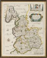
A Mapp Of Ye County Palatine Of Lancaster [Lancashire with Liverpool and the Mersey to the South, showing the boundaries of Cheshire and all the way up to Overton and Parts of Westmoreland to the North].
Vintage, handcoloured map (copper engraving). [Richard Blome / Britannia], 1673 Framed: 30 cm x 37 cm. Map itself: 28 cm x 35 cm. Excellent condition in beautiful 19th century framing.

![Haacken, Totentanz / [Dance of Death].](/images/thumbnails/100003AG.jpg)
![Pemberton, Blaawberg Strand [Bloubergstrand] (with shipwreck) and Hermanus.](/images/thumbnails/100009AG.jpg)