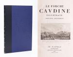
West Cork Rare BookfairINANNA MODERNWest Cork Reading Holidays
We ship per DHL Express

We ship per DHL Express

Roman Empire

Le Forche Caudine - Illustrate con due Appendici. [Compreso

[Daniele, Francesco / Johann Josef von Wilczek / Thomasius, Christian].

Le Forche Caudine – Illustrate con due Appendici. [Compreso “Prospetto Della Valle Caudina Dalla Parte Della Campania”]. Second edition, augmented and, according to Brunet, preferable to the original first edition, which was printed in Caserta in 1778.

Seconda Edizione. Napoli, Appresso Angelo Trani, 1811. Folio (44.5 cm x29 cm). XIII, (3), 102 pages plus (6) pages advertising and Index (Indice). With 22 (twentytwo) illustrations overall. Including a large fold-out-plan (97 x 43 cm) of the Valle Caudine, several Vignettes, Allegorical/Historical Illustrations and four beautiful landscape engravings of the Valle Caudine by Alessandro d’Anna / XIII, (3), 102 pagine più (6) pagine pubblicitarie e Index (Indice). Con 22 (ventidue) illustrazioni in totale. Tra cui una grande illustrazione (97 x 43 cm) della Valle Caudine, diverse vignette, illustrazioni allegoriche / storiche e quattro bellissime incisioni paesaggistiche della Valle Caudine di Alessandro d’Anna. Hardcover / Fantastic modern, Nigerian goatskin with gilt lettering on spine and fine quality late 19th-century cloth over boards. New endpapers and all bound in style by english master-binders. Excellent condition of the binding. The stunning and most wonderful interior with only very occasional signs of an old dampstain to the outer margins and the beautiful, large fold-out-plan with some mild browning to one part of the center-fold. A typographical masterpiece of italian printmaking.

EUR 1.280,-- 

Show details   Add to cart

The Roman History & The History of the Carthaginians  [Volume VI of

[Maylor, Paul – Lord Mayor of Cork City in 1811] Compiled from Original Authors.

The Roman History & The History of the Carthaginians [Volume VI of “A Universal History from the Earliest Account of Time to the Present”]. With the following maps and illustrations: 1.S. Wheatley – “A General Map of the Roman Empire shewing the Situation of all its Provinces & ye Seats of ye Barbarous Nations on their Frontiers” (51 cm x 36 cm) / 2. The Histoorical pillar, the serpentine pillar, the porphyry pillar, the pillar of the emperor Marcian; and the Hippodrome, with the Thebean obelisk and engines, by which it was erected / 3. “The Thracian Bosporus, with Constantinople divided into wards; the outside prospect and the whole view of the Church of Santa Sophia” [Hagia Sophia from “Du Fresne Lib. 3. Pag.1”] and the whole view of the Church Santa Sophia / 4. “A Map shewing the antient situation of Carthage, Utica, Tunes, and the Carthaginian bay; with a bird’s view of the situation of antient Carthage” / 5. “Two Siculo-Punic medals; the fashion of the aqueduct near Old Carthage; and the monstrous serpent killed by the Romans on the banks of the Bagrada”.

Volume VI. Dublin, George Faulkner, 1745. 23 cm x 36 cm. VI, 871 pages. Illustrated wtih Maps, Cuts, Notes, Chronological, and Other Tables. Original Hardcover. Good condition with signs of external wear, for example front cover and spine are worn and slightly rubbed. Slight discolouration to pastedown and endpaper. A dampstain fading from titlepage towards page 81 (the stain gets progessively smaller and smaller and is overall very pale and no nuisance). Interior and also the full-page engravings in excellent condition. The wonderful large folded map of the Roman empire in excellent condition besides a faded peripheral dampstain.

EUR 1.280,-- 

Show details   Add to cart

Page: 1
: