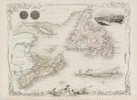
Nova Scotia and Newfoundland with Vignettes and illustrations of Halifax, Cod Fishery of Newfoundland. The Vignettes showing Cape Breton and Prince Edward Island, Anticosti Island and the mouth of the St.Lawrence River. The outher margins of the map beautifully illustrate the importance of the Cod Fishery to these regions by showing Cod on hooks. Also on the map a beautiful, large illustration of a Steamship with the fleet of Cod-Fishers behind it.
Original steel engraving / Vintage map. Drawn and engraved by John Rapkin. Partly hand-coloured. London & New York, J & F. Tallis, 1851. Plate Size: 25 cm x 32.5 cm. Sheet Size: 37.5 cm x 27.2 cm. Vintage 19th century map in very good condition.
EUR 275,--


