Inanna Rare Books

Inanna Rare Books

Inanna Rare Books

    • Home
    • About us
    • Shipping Information
    • Search File
    • Contact
    • Cart
    • Rare Book Room
      • Books on Books
      • History - Politics - Law
      • Literature
      • Philosophy & Religion
      • Social Sciences - Education
      • Medicine
      • The Arts
      • Travel & Exploration
      • Mathematics
      • Science & Technology
      • Farming - Fishing - Hunting
      • Natural History
      • Games - Sport
      • Complete Catalogue
    • Art & Map Gallery
      • Art Gallery
      • Rare Maps & Cartography
    • Manuscripts
      • Manuscripts - Literature
      • Manuscripts - History
      • Manuscripts - Travel
      • Manuscripts - Food
      • Manuscripts - Music
      • Manuscripts - Secret Knowledge
      • Manuscript Letters/Autographs
      • Manuscripts - Art
      • Manuscripts - Philosophy
    • Gift Ideas / New Arrivals
      • New Arrivals
      • Gift Ideas for Collectors
      • Gift Wrapping Available
      • Handmade Paper
      • Gift Wrapping Available
    • Inanna Publishing
    • Libraries & Collections
      • African Maps Collection
      • Henry David Aiken - Collection
      • Samuel Beckett - Collection
      • Walter Benjamin - Collection
      • Alexander Calder Collection
      • Castlefreke - Collection
      • Alice Curtayne Collection
      • Fly Fishing / Angling Collection
      • Vere Foster - Collection
      • William Daniel Gill Collection
      • John Minihan Collection
      • David (Dave) Naylor - Collection
      • David Puttnam Collection
      • Savigny Collection
      • Eric Ravilious Collection SOLD
    • Catalogues
    • News / Events
  • Advanced Search
  • List
    • Terms & Conditions
    • Return Policy
    • Privacy Policy
    • Shipping Information
    • Imprint
INANNA MODERNWest Cork Reading Holidays
We ship per DHL Express

We ship per DHL Express

Advanced Search
  • Rare Book Room
    • Books on Books
    • History - Politics - Law
    • Literature
    • Philosophy & Religion
    • Social Sciences - Education
    • Medicine
    • The Arts
    • Travel & Exploration
    • Mathematics
    • Science & Technology
    • Farming - Fishing - Hunting
    • Natural History
    • Games - Sport
    • Complete Catalogue
  • Art & Map Gallery
    • Art Gallery
    • Rare Maps & Cartography
  • Manuscripts
    • Manuscripts - Literature
    • Manuscripts - History
    • Manuscripts - Travel
    • Manuscripts - Food
    • Manuscripts - Music
    • Manuscripts - Secret Knowledge
    • Manuscript Letters/Autographs
    • Manuscripts - Art
    • Manuscripts - Philosophy
  • Gift Ideas / New Arrivals
    • New Arrivals
    • Gift Ideas for Collectors
    • Gift Wrapping Available
    • Handmade Paper
    • Gift Wrapping Available
  • Inanna Publishing
  • Libraries & Collections
    • African Maps Collection
    • Henry David Aiken - Collection
    • Samuel Beckett - Collection
    • Walter Benjamin - Collection
    • Alexander Calder Collection
    • Castlefreke - Collection
    • Alice Curtayne Collection
    • Fly Fishing / Angling Collection
    • Vere Foster - Collection
    • William Daniel Gill Collection
    • John Minihan Collection
    • David (Dave) Naylor - Collection
    • David Puttnam Collection
    • Savigny Collection
    • Eric Ravilious Collection SOLD
  • Catalogues
  • News / Events

Rare Maps – Africa (27 items)

Cape Colony with Clan William, Little Namaqua Land, Tulbagh or Karoo, Stellenbosch, The Cape

1. Africa / South Africa – Tallis, John / Rapkin, John. (1817 – 1876)

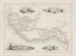
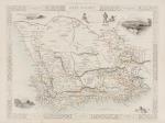
Cape Colony with Clan William, Little Namaqua Land, Tulbagh or Karoo, Stellenbosch, The Cape, Zwellendam, George, Zitzikamma, Uitenhage, Beaufort, Graaf Reynet, Albany, Somerset, Victoria, Colesberg, Griquas. With Vignettes and illustrations of Cape Town, Entrance to the Knysna, Graham’s Town.

Original steel engraving / Vintage map. Drawn and engraved by John Rapkin. Partly hand-coloured. London & New York, J & F. Tallis, 1851. Plate Size: 32 cm x 26 cm. Sheet Size: 37.4 cm x 27.2 cm. Vintage 19th century map in very good condition.

Show details

Tallis, Western Africa - with Senegambia, Guinea

2. Tallis, John / Rapkin, John. (1817 – 1876)

Western Africa – with Senegambia, Guinea (Ashantee / Dahomey, Benin) / Liberia etc. – with Vignettes and illustrations of Sierra Leone and Bakel, a Cape Coast Castle, Christiansborg (Danish Gold Coast / Osu Castle).

Original steel engraving / Vintage map. Drawn and engraved by John Rapkin. Partly hand-coloured. London & New York, J & F. Tallis, 1851. Beautifully Framed. Size of the Frame with map: 50 cm x 41 cm. Size of the actual map: 27 cm x 37 cm. Very good condition.

Show details

Sanson d'Abbeville, Partie de la Coste de Barbarie en Afrique

3. North Africa – Sanson d’Abbeville, Nicolas. (1600 – 1667).

Partie de la Coste de Barbarie en Africque, ou sont le Royaumes de Tunis, et Tripoli et Pays Circomvoisins Tires de Sanuto et d’autres.

Original hand-coloured engraving. Paris, Chez P. Mariette, 1655. Plate Size: 53.2 cm x 36.7 cm. Sheet Size: 61.3 cm x 45.7 cm. Original map. In very good condition with only the faintest traces of browning outer margins. Minor tear to margins along centre fold. Discreet inked numeration in top right corner of sheet.

Show details

Tallis, Africa - The African Continent with Vignettes

4. Africa – Tallis, John / Rapkin, John. (1817 – 1876)

Africa – The African Continent with Vignettes and illustrations of an Arab family of Algeria, Bosjesman Hottentots Wild Bushmen, St.Helena, Korranna Hottentotts, Bedouin Arabs Encampment.

Original steel engraving / Vintage map. Drawn and engraved by John Rapkin. Partly hand-coloured. London & New York, J & F. Tallis, 1851. Plate Size: 32.4 cm x 25 cm. Sheet Size: 37.4 cm x 27.4 cm. Vintage 19th century map in very good condition.

Show details

Tallis, Egypt and Arabia Petrea - with Vignettes and illustrations of the Mosque

5. Africa / North Africa – Tallis, John / Rapkin, John. (1817 – 1876)

Egypt and Arabia Petrea – with Vignettes and illustrations of the Mosque of Sultan Hassan / Grand Cairo / Alexandria / Ruins of the Great Temple, Karnac / Great Sphinx, Ghizeh / Gulf of Akaba / Gulf of Suez / Red Sea with Boats / .

Original steel engraving / Vintage map. Drawn and engraved by John Rapkin. Partly hand-coloured. London & New York, J & F. Tallis, 1851. Plate Size: 24.5 cm x 34.4 cm. Sheet Size: 27.3 cm x 37.4 cm. Vintage 19th century map in very good condition.

Show details

Vaugondy, Karte von Egypten.

6. Egypt – Vaugondy, Robert. (1723 – 1786).

Karte von Egypten.

Original hand-coloured engraving. Augsburg, Joh. Walch, 1798. Plate Size: 54.5 cm x 49.2 cm. Sheet Size: 67.3 cm x 55.1 cm. Original map. In very good condition. Large margin between plate and sheet edges. Some spotting along sheet edges beyond map border. Central vertical fold as issued. Map is orientated to the north.

Show details

Hand-coloured border with latitudinal and longitudinal lines. Coloured interior map borders. Very interesting and decorative map of the east coast of Africa (in modern-ay Mozambique), which was then u

7. East Africa – Zatta, Antonio. (1722 – 1804).

Parte Della Costa Orientale Dell’Africa con l’Isola dei Madagasear e le Carte particolari dell’Isole di Francia e di Borbon.

Original hand-coloured engraving. Venezia, Antonio Zatta E Figli, 1784. Plate Size: 40 cm x 30.5 cm. Sheet Size: 51 cm x 38.8 cm. Original map with good margins. Very good condition, with the only slightest traces of browning to outer margins.

Show details

Zatta, L'Egitto Antico E Moderno.

8. Egypt – Zatta, Antonio. (1722 – 1804).

L’Egitto Antico E Moderno.

Original hand-coloured engraving. Venezia, Antonio Zatta E Figli, 1784. Plate Size: 31 cm x 40 cm. Sheet Size: 39 cm x 50.7 cm. Original map. Very good condition, with the slight traces of staining to lower section of map.

Show details

Zatta, La Guinea Occidentale.

9. Equatorial Guinea – Zatta, Antonio. (1722 – 1804).

La Guinea Occidentale.

Original hand-coloured engraving. Venezia, Antonio Zatta E Figli, 1784. Plate Size: 31 cm x 40 cm. Sheet Size: 51.7 cm x 38.8 cm. Original map. Very good condition. Map orientated to the north. Very minor foxing along top edge of sheet.

Show details

Zatta, Le Coste Di Barbaria

10. North Africa – Zatta, Antonio. (1722 – 1804).

Le Coste Di Barbaria Ovvero I Regni di Marocco di Fez di Algers di Tunisi di Tipoli coi Paesi Circonvicini.

Original hand-coloured engraving. Venezia, Antonio Zatta E Figli, 1784. Plate Size: 41.5 cm x 30.5 cm. Sheet Size: 50.6 cm x 38.8 cm. Original map with generous margins. Very good condition, with the only slightest traces of browning.

Show details

Page: 1 2 3
:

Order by: Author · Title · Keyword · Year · Price (up) · Price (down) · Inventory Number · Recent Changes · Relevance

Books per page: 10 · 20 · 50 · 100

Contact

Inanna Rare Books Ltd.
Woodley House
Castletownshend Road
P81 D262 Skibbereen, County Cork
Ireland
Phone: ++353 - (0) 87 - 102 5412
E-Mail: info@inannararebooks.com
Internet: https://www.inannararebooks.com

Online Bookshop specialized in rare
and secondhand books.

Newsletter and E-Catalogue Sign Up

Enter your name and e-mail address to sign up for
our regular newsletter and catalogue service.

Payment Options

Paypal   Master Card   VISA   American Express

Legal Info

  • Terms & Conditions
  • Return Policy
  • Privacy Policy
  • Shipping Information
  • Imprint

© 2026 Inanna Rare Books Ltd. | Powered by HESCOM-Software