


Zatta, Parte Della Costa Orientale Dell'Africa con l'Isola dei Madagasear e le C
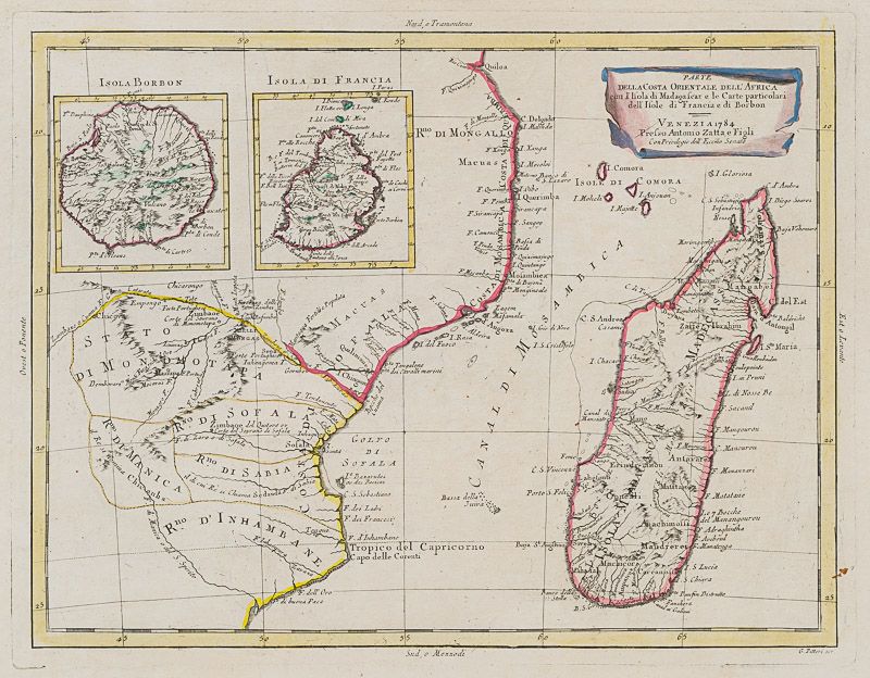
Parte Della Costa Orientale Dell’Africa con l’Isola dei Madagasear e le Carte particolari dell’Isole di Francia e di Borbon.
Original hand-coloured engraving. Venezia, Antonio Zatta E Figli, 1784. Plate Size: 40 cm x 30.5 cm. Sheet Size: 51 cm x 38.8 cm. Original map with good margins. Very good condition, with the only slightest traces of browning to outer margins.
Hand-coloured border with latitudinal and longitudinal lines. Coloured interior map borders. Very interesting and decorative map of the east coast of Africa (in modern-ay Mozambique), which was then under Portuguese rule. Also included are two maps of Isola Borbon (Reunion Island) and Isola di France (Mauritius). The shows the administrative divisions, cities, towns, coastal towns, mountains and rivers. Smaller islands off the African coast, such as the French-controlled ‘Isole di Comora’ (Comoros). The Tropic of Capricorn runs across the lower section of the map.
Decorative title cartouche in the top right corner of the map.
From Zatta’s monumental Altante Novissimo, one of the last great decorative atlases of the 18th Century.
Antonio Zatta (1722-1804) was an Italian cartographer and publisher who was based in Venice. One of his major contributions include the Atlante Novissimo, a four-volume atlas of the world. He is also known for his prolific output of prints and books that were both precisely made and aesthetically pleasing. Zatta clearly had a large network from which to draw information; this is how he was able to publish the first glimpse of the islands visited by Captain Cook in the Atlante Novissimo. Zatta also published books of plays and architecture.
- Keywords: 18th Century · 18th Century Maps · Africa · Cartography · Catalogue No.5 – Maps of the World · East Africa · East Africa Map · French Africa · Indian Ocean · Italian · Library & Collection Building · Madagascar · Map · Map, African · Mozambique · Original Engraving · Original Map · Original Maps · Portuguese Imperialism Colonialism · Rare Map Africa · Rare Maps Collection – Africa · Vintage Map
- Inventory Number: 200044AG


Contact
Inanna Rare Books Ltd.
Woodley House
Castletownshend Road
P81 D262 Skibbereen, County Cork
Ireland
Phone: ++353 - (0) 87 - 102 5412
E-Mail: info@inannararebooks.com
Internet: https://www.inannararebooks.com
Online Bookshop specialized in rare
and secondhand books.
Newsletter and E-Catalogue Sign Up
Payment Options


© 2026 Inanna Rare Books Ltd. | Powered by HESCOM-Software
Follow Us

