West Cork Rare BookfairINANNA MODERNWest Cork Reading Holidays
We ship per DHL Express

We ship per DHL Express

Travel Scotland – Rare

Cary's New Itinerary: Or an Accurate Delineation of the Great Roads, Both Direct and Cross throughout England and Wales: With Many of the Principal Roads in Scotland.

Cary, John.

Cary’s New Itinerary: Or an Accurate Delineation of the Great Roads, Both Direct and Cross throughout England and Wales: With Many of the Principal Roads in Scotland. From an Actual Admeasurement by John Cary: Made by Command of his Majesty’s Postmaster General for official purposes: Under the Direction and Inspection of Thomas Hasker Esq., Surveyor and Superintendant of the Mail Coaches. [Including an advertising for Cary’s New Celestial and Terrestrial Globes (with Illustrations of Globes)]. [Subtitle:] This work shows the immediate Route from the Metropolis [London] to all parts of England and Wales: And from Town to Town in every direction, distinguishing also the Cities, Market, Borough and Corporate Towns: And those at which the Assizes are held and gives the time of the Mails, Arrival and Departure from each, Describes the Line of the Navigable Canals and the Course of the Rivers passed over, The Number of Houses and Inhabitants contained in each Town, And those Inns which supply Post Horses and Carriages. Also The Inn’s throughout the Metropolis [London] from which the Mail and Stagecoaches go, their time of departure & the Route they seveerally take. The Noblemen and Gentlemen’s Seats situate near the Roads, A List of the Packet Boats and their time of sailing. Copious Indexes. Maps of the Lot Wight Environs of London, Bath, Brighton, Margate & Cheltenham & a Large Map of England and Wales peculiarly adapted to the Work. – [An Advertisement juxtaposed to the titlepage reads: “This Edition contains the Routes to upwards of Nine Thousand Places, which have never been given in any work of a similar Description; being a complete Directory to every Parish situate out of the Line of the Direct and Cross Roads throughout England and Wales”].

Seventh Edition, with Improvements [complete with all maps as called for]. London, Printed for J. Cary, 1817. Octavo. Pagination: [1], 647 pages plus 7 maps / Detailed pagination see here: [1], Title, Large Folding Map, [121], 6 folded Maps, [526] pages. Modern, recent Hardcover / Very decorative half-leather with marbled-paper-covered boards. Gilt lettering on new sppine-label. New endpapers. Protective Mylar. Only the large folding map with a inor tear (one part of the map deliberately bound separate (geniously folding out to meet th erest of the map). Interior text and maps all in excellent, unusually clean condition !!

EUR 780,-- 

Show details   Add to cart

Gilpin / Castle Freke Library - Observations Relative Chiefly to Picturesque Beauty, Made in the Year 1776

Gilpin, William. [Castle-Freke Library Bookplates]

Collection of four Volumes (bound in two) by Gilpin – All from the historical library at Castle Freke (Castlefreke, West Cork / Ireland). The Volumes include: I. & II. Observations Relative Chiefly to Picturesque Beauty, Made in the Year 1776, on Several Parts of Great Britain; particularly the High-Lands of Scotland. [Second Edition, with an “Account of the Prints” bound to the rear] / III. Observations on the River Wye and several Parts of South Wales &c. relative chiefly to Picturesque Beauty; Made in the summer of the Year 1770 (Third Edition). / IV. An Essay on Prints – [″The chief intention of the following work was to put the elegant amusement of collecting prints, on a more rational footing; by giving the unexperienced collector a few principles and cautions to assist him”] (Fourth Edition with the printed dedication “To the Honorable Horace Walpole in Deference to his Taste in the Polite Arts; and the Valuable Researches he has made to improve them; the following work is inscribed by his most obedient and very humble servant, William Gilpin”). [Volumes I & II with 40 original illustrations and vintage 18th century maps [correctly 39 illustrations and one table], for example of Loch Lomond and the Firth of Forth/ all illustrations are vintage mezzotint-plates].

Mixed Editions. Four Volumes (bound in two). London, Printed for R. Blamire, Strand, 1792. Octavo. Pagination: Volume I: XI, [1], 221 pages with 24 mezzotints / Volume II: 195, XVI pages with 16 mezzotints and an “Account of the Prints” as well as “Translations of Latin Passages” / [Volume III]: [River Wye]: XVI, 152 pages with 16 (of 17) full – page mezzotints / [Volume IV]: [An Essay on Prints]: XIII, [3], 174 pages plus XI pages Index and 1 page Errata. Hardcover / Early 19th century quarter – morocco with gilt lettering and ornament on spine. Both volumes bound in unison. Very good + condition with only minor signs of external wear. Pages 185 – 191 of Volume I with some stronger browning. Otherwise the interior very clean. All mezzotints in very good or even better condition. This is the original copy from the historical Castle-Freke Library in West Cork (Ireland), with two armorial bookplates to front and rear pastedown with the family’s motto ‘Pro Patria’. With two pages of manuscript annotations by a contemporary hand with a reference between the common name “Tarbet” in Scotland and a place-name in County Kerry in Ireland” (pages 13 of Volume II) / another entry is on page 12 of Volume II regarding the name-sake “Loch-Loung” for a Lake of ships in Scotland and Ireland.

Show details

Jean-Denis Barbié du Bocage - Tableau de la Grande-Bretagne, De L'Irlande et des Possessions Angloises dans les quatre parties du Monde. [Large Paper Copy / Better Paper Copy / Exemplaire de Luxe]

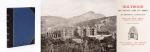
Pugilism (Boxing) – Baert-Duholant, Charles-Alexandre-Balthazar-François de Paule baron de / Jean-Denis Barbié du Bocage.

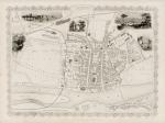
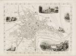
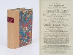
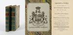
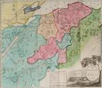
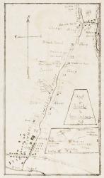
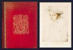
Tableau de la Grande-Bretagne, De L’Irlande et des Possessions Angloises dans les quatre parties du Monde. [Large Paper Copy / Better Paper Copy / Exemplaire de Luxe] [With five (5) large, folded Maps by Jean-Denis Barbié du Bocage: Large, oblong folded Map/Plan of Gibraltar / England / Scotland / Ireland / India] / [With four (4) stunning copper-engravings: Grotte de Fingal, Chaussée des Géants / Plan et vue de Gibraltar / Combat de Boxe (Pugilists)] / [With two (2) portraits: 1.Portrait of William Pitt (after William Owen) and 2. Portrait of Charles Jacques Fox (after Karl Anton Hickel)].

Four Volumes (complete set). Paris, Chez H.J.Jansen, L’An 8me [1800]. Octavo (21.5 cm x 14 cm). Collation: Volume I: (8), 459, (1), 11 pages with Eleven (11) copper-engravings of which are: 5 Maps / Plans and 4 Engravings: The folded view of Fingals Cave (″Grotte de Fingal dans l’Ile de Staffa” – (20.5 cm x 31.5 cm) / “Folded Plate of the Giants Causeway (″Vue occidentale de la Chaussee des Geans et des Caps voisins” (20.5 cm x 39 cm)) / Fantastic, large Map/Plan of Gibraltar by Jean-Denis Barbié du Bocage, with a Birds-Eye-View of the Ville de Gibraltar (20.5 cm x 65.5 cm) [also showing the Ville Irlandaise on Gibraltar] / Scenic View of Gibraltar (″Vue de Gibraltar, prise du cote de l’Espagne” (20.5 cm x 33 cm) / Large Fold-Out-Map of England by Jean-Denis Barbié du Bocage with an Inset-View of Stonehenge (47 cm x 51 cm) / Large Fold-Out-Map of Scotland by Jean-Denis Barbié du Bocage, including the Western Isles and Shetland, with a stunning Inset-View of the irish pilgrimage-mountain Croagh Patrick [Craig-Phadrick] in Westport, Ireland (37 cm x 50 cm)/ Large Fold-Out-Map of Ireland with an Inset-View of the Lakes of Killarney (39 cm x 44.5 cm) / Volume II: 532, (1), 12 pages with Large Fold-Out-Map of India (″Possessions Anglaises”) by Jean-Denis Barbié du Bocage – the large India-Map showing areas as far as Tibet, Siam, Sumatra and the Andaman Islands, Ceylon, Burma (48 cm x 43 cm) / Volume III: 502, 48, (2) pages with two portraits: Guillaume Pitt [William Pitt] & Charles Jacques Fox (each 20.5 cm x 12.5 cm)/ Volume IV: 486, 22, (2) pages with the very famous Fold-out-Illustration of Pugilists / Boxers at Odiham in Hampshire [″Combats de Boxers a Odiham”] showing a boxing-match between Humphrey and Mendoza (32 cm x 20.5 cm). Hardcover / Original, very decorative original half leather bindings with gilt lettering and ornament on spine. Volume One professionally rebacked by an english master bookbinder. All four Volumes in protective Collector’s Mylar. Excellent condition with only minor signs of external wear. From the library of François-Xavier de Valenzi with his bookplate / exlibris to the pastedowns of each Volume. Maps in this de Luxe Edition are all considerably larger than in the normal-paper-edition and all the maps and illustrations are in superb condition. An underestimated collectable.

EUR 2.200,-- 

Show details   Add to cart

Page: 1 2
: