Ortelius, Fezzae et Marocchi Regna Africae Celeberrima, describebat Abrah Orteli
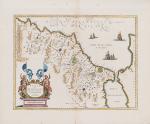
Fezzae et Marocchi regna Africae celeberrima, describebat Abrah Ortelius.
Original hand-coloured engraving. Amsterdam, Blaeu, [c.1650]. Plate Size: 49.5 cm x 38 cm. Sheet Size: 61.4 cm x 51.5 cm. Original, well-margined map. Very good, actually stunning condition. Tiny paper defect and minor tear to outer margins. Repaired minor tear to centre fold at lower edge of sheet. Some minor spotting to margins only. Hint of browning along centre fold. The map was orientated with Morocco’s north to the right.
[Koeman II, 8615:2].
Hand-coloured border with latitudinal and longitudinal lines along margins. A highly decorative map of Morocco showing the kingdom of Morocco and kingdom of Fez. Cadiz and the southern part of Spain can be seen. Villages and towns are shown as miniature views, also mountains and rivers are engraved on the map. An active volcano is depicted above Campos de Anget.
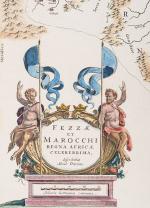
Decorative title cartouche, adorned with two crowns, shows two satyrs, each holding javelins/poles flying blue pennant. Five ships are depicted off the Strait of Gibraltar. Ortelius is credited in the title as the map source
Abraham Ortelius was a Flemish cartographer and geographer, conventionally recognized as the creator of the first modern atlas, the Theatrum Orbis Terrarum (Theatre of the World). He was one of the most notable figures of the Dutch school of cartography during its golden age (approximately 1570s-1670s).
- Keywords: 17th Century · Africa · Africa, North · Cartography · Catalogue No.5 – Maps of the World · Library & Collection Building · Map · Map, African · Morocco · Morocco Map · North Africa · Original Engraving · Original Map · Original Maps · Rare Map Africa · Rare Maps Collection – Africa · Vintage Map
- Inventory Number: 200004AG
© 2025 Inanna Rare Books Ltd. | Powered by HESCOM-Software


