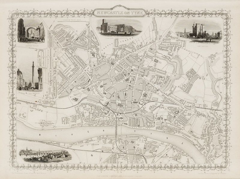
Tallis, Newcastle on Tyne - With Vignettes of High Level Bridge, Grey Monument,
Newcastle on Tyne – With Vignettes of High Level Bridge, Grey Monument, Railway Bridge, Central Station and The Castle.
Original steel engraving / Vintage map. Drawn and engraved by John Rapkin. Illustrated and Engraved by H. Winkles. London & New York, The London Printing and Publishing Company, 1851. Plate Size: 33.5 cm x 25.5 cm. Sheet Size: 37.5 cm x 27 cm. Vintage 19th century map in very good condition.
Published in the Illustrated Atlas, And Modern History Of The World Geographical, Political, Commercial & Statistical, Edited By R. Montgomery Martin.
Handsome town-plan of Newcastle, in England’s Northeast, bordered to the south by the Tyne, with Gateshead across the river. Railway, street and district areas of the city are also included. Decorative scrolling and title cartouche around the edges of the image.
The project of ‘The Illustrated Atlas’ was designed to be finished just in time for the anxiously awaited “Great Exhibition of the Works of Industry of All Nations” or The Great Exhibition, sometimes referred to as the Crystal Palace Exhibition in reference to the temporary structure in which it was held, was an international exhibition that took place in Hyde Park, London, from 1 May to 11 October 1851. It was the first in a series of World’s Fairs, exhibitions of culture and industry that became popular in the 19th century, and it was a much-anticipated event.
The Great Exhibition was organized by Henry Cole and Prince Albert, husband of the reigning monarch, Queen Victoria. It was attended by numerous notable figures of the time, including Charles Darwin, Samuel Colt, members of the Orléanist Royal Family and the writers Charlotte Brontë, Charles Dickens, Lewis Carroll, George Eliot and Alfred Tennyson. Music for the opening was under the direction of Sir George Thomas Smart and the continuous music from the exhibited organs for the Queen’s procession was “under the superintendence of William Sterndale Bennett”. (Wikipedia)
- Keywords: 19.Jahrhundert · 19th Century · 19th Century Map · Britain · British Maps · Cartography · Catalogue No.5 – Maps of the World · City · City / Town Plans · England · English History – Rare · John Tallis Maps · Map · Original Map · Original Maps · Original Steel Engraving · Rare Map – England · Rare Map – Europe · Travel England – Rare · Travel Europe – Rare · Vintage Map · Vintage Old Map
- Language: English
- Inventory Number: 200127AG
EUR 350,--
© 2025 Inanna Rare Books Ltd. | Powered by HESCOM-Software


