Books with vintage Maps (65 items)

Nathaniel Hooke - The Roman History, From the Building of Rome to the Ruin of the Commonwealth

41. Hooke, Nathaniel.

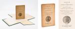
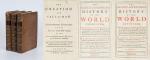
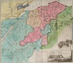
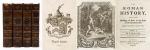
The Roman History, From the Building of Rome to the Ruin of the Commonwealth [with the printed Dedication to Alexander Pope]. Illustrated with 17 folding Maps, 4 Fontispieces and 11 other Plates [32 copper-engravings in total].

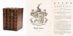
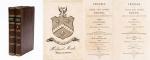
The Fourth Edition. Four Volumes (complete set with all maps and plates). London, Printed for J. and R. Tonson; Hawkins and T.Longman, 1766 – 1771. Quarto (27 cm x 22 cm). Collation: Volume I: Frontispiece, XLVI, XLVI, 634 pages with 10 plates and 3 maps / Volume II: Frontispiece, XXXII, XXXII, 668 pages with 8 maps / Volume III: Frontispiece, VI, 694 pages with 5 maps / Volume IV: Frontispiece, VII, 464 pages plus 76 unnumbered pages of a General Index and 1 plate and 1 map. Hardcover / Original 18th-century leather with gilt lettering and labels on spine. Interior of this set with all maps and illustrations in excellent, very clean condition. The boards of the bindings with abrasions and some bumping but overall very firm. Some stronger peeling of the leather on board of Volume I, Only three pages with minor tears. The large map of Northern Africa (Palestine, Egypt and Libya) with a minor tear. The stunning maps and plates in timeless beauty. Highly underestimated work, in the shadow of Gibbon but with meticulous detail in presenting the geographical impact of the Roman Conquest. From the library of Daniel Conner (Connerville / Manch House), with his Exlibris / Bookplate to pastedown.

EUR 3.500,-- 

Show details   Add to cart

John Campbell, Lives of the Admirals, And other eminent British Seamen

44. Campbell, John.

Lives of the Admirals, And other eminent British Seamen; containing Their Personal Histories, and a Detail of all their Public Services. Including A new and accurate Naval History, from the earliest Account of Time; and clearly proving by a continued Series of Facts, our uninterrupted Claim to, and Enjoyment of, the Dominion of our Seas. Interspersed With many curious Passages, relating to our Discoveries, Plantations and Commerce. Supported throughout by proper Authorities.

The Third Edition. In Four Volumes (complete set). London, Printed for T.Osborne, C.Hitch and L.Hawes, H.Woodfall, J.Rivington and others, 1761. Octavo (13.5 cm x 20.5 cm). Pagination [see full list of maps and portraits below the description]: Volume I: 587 pages with one folded map and two portraits / Volume II: 580 pages with one folded map and two portraits / Volume III: 488 pages with two fold-out maps / Volume IV: 519 pages with two fold-out maps. Hardcover / Original 18th century – calf with gilt ornament and original spine-labels [of which one spine-label has been recently replaced in matching style]. Bindings all firm and with only minor signs of wear and bunping to top and bottom of spine’s. Interior, Maps and Portraits all in excellent condition. Very inor, faded dampstain to the outer margins of some pages of Volume III. From the library of Daniel Conner (Connerville / Manch House), with his Exlibris / Bookplate to pastedown.

EUR 1.480,-- 

Show details   Add to cart

Shuckford, The Sacred and Profane History of the World connected

48. Shuckford, Samuel.

The Sacred and Profane History of the World connected, Frome the Creation of the World to the Dissolution of the Assyrian Empire at the Death of Sardanapalus, and to the Declension of the Kingdoms of Judah and Israel, under the Reigns of Ahaz and Pekah. [Together with: “The Creation and Fall of Man” – “A Supplemental Discourse to the Preface of the First Volume of the Sacred and Prophane History of the World connected”].

The Third Edition. 3 Volumes (of 4). London, Printed for J. and R. Tonson and S. Draper in the Strand, 1753. Octavo. LXIV,366, [10], LV, 461, [10], CXXXII, 295, [16] pages. Each Volume with its own Index. Includes two folded maps in Volume One: First Map: “A Plan of the present Chanels [sic] of the Rivers Hiddekel or Tigris and Euphrates exhibiting the Site of Moses Garden and River of Eden” / Second Map: “The Situation of the Land & Garden of Eden together with the Rivers of Paradise as they are imagined to have been Situate by some Writers who thought that the Garden of Eden was planted in that which was afterwards called the Holy Land”. Original Hardcover / 18th century full leather with new spinelabels. All three Volumes are now in protective Mylar. with dustjacket. All Volumes with some damage to spine but all still firm and holding. Overall some faint staining and foxing only at very few locations because of the excellent paper-quality of this publication. From the library of Daniel Conner (Connerville / Manch House), with his Exlibris / Bookplate to pastedown.

EUR 275,-- 

Show details   Add to cart

Page: 1 2 3 4 5 6 7
: