![Caesar, [De Bello Gallico]](/images/thumbnails/27073AB.jpg)
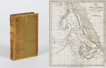
[De Bello Gallico / De Bello Alexandrino / De Bello Africano / De Bello Hispaniensi ] C. Julii Caesaris Quae Extant Omnia. Ex Recensione Joannis Davisii, Coll. regin. Cantab. Socii, cum Ejusdem Animadversionibus ac Notis Pet. Ciacconii, Fr. Hotomanni, Joan. Brantii, Dionys Vossii et aliorum. Accessere Metaphrasis Graeca. Librorum VII. De Bello Gallico. Nec Non Indices necessarii.
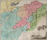
Cantabrigiae [Cambridge], Typis Academicis Impensis Joannis Owens, 1706. Quarto. (4), 751, (5), 96 pages plus 34 pages Index. Including two folded maps (Gallia / Pompeium aer Caesarem (Mare Mediterraneum with Southern Europe and North Africa/Asia Minor) and one folded illustration: “Pontis Figura a Caesare decem diebus ad Rhenum trajiciendum effecti” / (4), 751, (5), 96 Seiten plus 34 Seiten Index mit zwei Faltkarten von Gallien und dem Mittelmeerraum sowie einer gefalteten Abbildung einer Behelfsbrücke über den Rhein. Full 18th century calf with gilt lettering on spine and emblemata of Charles-Marie-Raymond Duc d’Arenberg. Very good +/ Near Fine condition with only minor signs of wear and a faded dampstain throughout. Exlibris of “Comte Goblet d’Alville” on pastedown / Sehr guter Zustand mit nur ganz geringen Gebrauchsspuren und einem durchgehenden, aber ganz dezent verblassten Wasserrand. Mit dem Exlibris des “Compte Goblet d’Alville. Wappensupralibro des Duc d’Arenberg.
EUR 480,--
![[Geographia Antiqua] Christophori Cellarii Smalcaldensis Geographia Antiqua](/images/thumbnails/31342AB.jpg)
![Sir George Douglas, A History of The Border Counties - Roxburgh, Selkirk, Peebles [with Maps]](/images/thumbnails/27127AB.jpg)