West Cork Rare BookfairINANNA MODERNWest Cork Reading Holidays
We ship per DHL Express

We ship per DHL Express

18.Jahrhundert (32 items)

Philip Luckombe, The Compleat Irish Traveller [Luxury Reprint with all of Charles Smith's Illustrations of 18th century Ireland (Munster / Kerry / Waterford) in separate Folder for Framing]

5. [Luckombe, Philip / Smith, Charles].

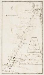
Luxury Reprint of “The Compleat Irish Traveller” [With high quality Reproductions of the 31 original Plates of detailed Maps of County Cork in the 18th century, County Kerry in the 18th century and Waterford in the 18th century, as well as some of the earliest engravings of Irish Towns here for the first time reproduced as beautiful Artworks for framing and housed in a special, handmade Folder. The publication was just recently enlarged with a detailed, Topographical Index (July 2023)]. Complete Title: “The Compleat Irish Traveller, containing A general Description of the most Noted Cities, Towns, Seats, Buildings, Loughs &c. in the Kingdom of Ireland, Interspersed with Observations on the Manners, Customs, Antiquities, Curiosities and Natural History of that Country. With Elegant Copper Plates”. [With 31 original Plates after Charles Smith, including Frontispiece, this Reprint / Facsimile is the result of 10 years of research and purchase of three (3) original versions of the First Edition from the year 1788. The first Editions known to Inanna Rare Books all had different quantities of Plates and Maps included. This Reprint by Inanna Rare Books has been produced from an extremely clean version of the original and shows the most complete set of illustrations and XL-Size Maps and Artworks we could find in any of the original editions. The publication shows not only Maps of County Cork, County Kerry and County Waterford but also Views of Irish Cities and Towns in these Counties of the Province of Munster and besides the wonderful Historical Plan of Cork City this set also includes the very rare Plan of the “Grand Canal from Dublin to the River Shannon” (see detailed list of all the illustrations present at the end of this description)].

Luxury Limited-Edition-Reprint of the First Edition by Luckombe in 1788. Two Volumes plus extra Folder with 31 Plates reprinted as Artworks for framing. Skibbereen (County Cork), Inanna Rare Books Publishing, 1788. Octavo (13.5 cm x 21 cm). Pagination: Volume I: Frontispiece, engraved Titlepage, XXX, 189 pages plus recently published Index (July, 2023) / Volume II: Engraved Titlepage, 263 pages plus recently published Index (July, 2023). Plus large, bespoke made Folder with thirtyone (31) Reproductions of the Maps, Plans and Illustrations which usually were folded inside this publication and now for the first time have been liberated from the book and were published as the beautiful works of art they are. Textvolume: Volume I and II of the text bound in one beautiful half-leather-volume with gilt lettering on spine, bound in the style of the 18th century / Illustrations-Folder with 31 reprinted illustrations of Towns and Maps of Ireland but mainly of Munster, bound in bespoke made half-cloth with paper-covered boards and pasted Reprint of the original titlepage. Excellent, new condition. One of only 300 printed. [Inanna Rare Books – Reprint & Facsimile – Series].

EUR 2.480,-- 

Show details   Add to cart

[Wilson, The Universal Gazetteer: or a Description of the several Empires,

6. [Wilson, Peter / Martin, Benjamin].

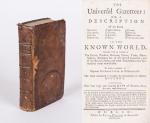
The Universal Gazetteer [Very Rare Dublin Edition] : or a Description of the several Empires, Kingdoms, States, Provinces, Countries, Cities, Towns, Seas, Lakes, Rivers, Mountains, Volcanos &c. in the Known World. Together with an Account of The Extent, produce, Revenue, Forces, Trade, Manufacturer, Religions &c. of the several Countries and of the Battles, Sieges and other Transactions that have sendered them remarkable. To which is prefixed a copious Introduction to Geography. The whole calculated to explain the Occurences in Modern History. Illustrated with four large and accurate Maps of Europe, Asia, Africa and America (only the Map of Asia is present: “New & Correct Map of Asia – Drawn from the latest and best Authorities by J. Gibson”). The Second Edition, in which several necessary Corrections and Material Additions have been made; the Geography of Ireland has been revised and enlarged; about four hundred entire new Articles have been added, chiefly relative to North America and Ireland, none of which are contained in the London Impression, and comprising in the whole, many thousand Places more than any other Gazzetteer; Whereby it is rendered the largest, cheapest, and most compleat Work of the Kind extant.

Dublin, Printed for Peter Wilson in Dame-Street, 1759. Small Octavo. XXXVIII, (1), 512 unnumbered pages (collation complete) with only the folded Map on Asia present and the other three maps missing. Including 6 pages of “Books, printed for and sold by Peter Wilson, in Dame-Street”. Original Hardcover (full calf on five raised bands with original spinelabel intact). Half a page in chapter “M” torn out. Faint dampstain throughout. Otherwise in very good condition. Binding rubbed and bumped on the corners but absolutely firm and tight. Minor traces of foxing and staining only. Name of preowner in 17th or 18th century ink on endpaper: “Daniel Eugene MacNamara”. Very rare Dublin Edition of this publication with a full-page recommendation of the famous Lexicographer Benjamin Martin.

EUR 1.200,-- 

Show details   Add to cart

Page: 1 2 3 4
: