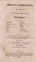
West Cork Rare BookfairINANNA MODERNWest Cork Reading Holidays
We ship per DHL Express

We ship per DHL Express

Roman History (17 items)

Le Forche Caudine - Illustrate con due Appendici. [Compreso

6. [Daniele, Francesco / Johann Josef von Wilczek / Thomasius, Christian].

Le Forche Caudine – Illustrate con due Appendici. [Compreso “Prospetto Della Valle Caudina Dalla Parte Della Campania”]. Second edition, augmented and, according to Brunet, preferable to the original first edition, which was printed in Caserta in 1778.

Seconda Edizione. Napoli, Appresso Angelo Trani, 1811. Folio (44.5 cm x29 cm). XIII, (3), 102 pages plus (6) pages advertising and Index (Indice). With 22 (twentytwo) illustrations overall. Including a large fold-out-plan (97 x 43 cm) of the Valle Caudine, several Vignettes, Allegorical/Historical Illustrations and four beautiful landscape engravings of the Valle Caudine by Alessandro d’Anna / XIII, (3), 102 pagine più (6) pagine pubblicitarie e Index (Indice). Con 22 (ventidue) illustrazioni in totale. Tra cui una grande illustrazione (97 x 43 cm) della Valle Caudine, diverse vignette, illustrazioni allegoriche / storiche e quattro bellissime incisioni paesaggistiche della Valle Caudine di Alessandro d’Anna. Hardcover / Fantastic modern, Nigerian goatskin with gilt lettering on spine and fine quality late 19th-century cloth over boards. New endpapers and all bound in style by english master-binders. Excellent condition of the binding. The stunning and most wonderful interior with only very occasional signs of an old dampstain to the outer margins and the beautiful, large fold-out-plan with some mild browning to one part of the center-fold. A typographical masterpiece of italian printmaking.

EUR 1.280,-- 

Show details   Add to cart

Nathaniel Hooke - The Roman History, From the Building of Rome to the Ruin of the Commonwealth

9. Hooke, Nathaniel.

The Roman History, From the Building of Rome to the Ruin of the Commonwealth [with the printed Dedication to Alexander Pope]. Illustrated with 17 folding Maps, 4 Fontispieces and 11 other Plates [32 copper-engravings in total].

The Fourth Edition. Four Volumes (complete set with all maps and plates). London, Printed for J. and R. Tonson; Hawkins and T.Longman, 1766 – 1771. Quarto (27 cm x 22 cm). Collation: Volume I: Frontispiece, XLVI, XLVI, 634 pages with 10 plates and 3 maps / Volume II: Frontispiece, XXXII, XXXII, 668 pages with 8 maps / Volume III: Frontispiece, VI, 694 pages with 5 maps / Volume IV: Frontispiece, VII, 464 pages plus 76 unnumbered pages of a General Index and 1 plate and 1 map. Hardcover / Original 18th-century leather with gilt lettering and labels on spine. Interior of this set with all maps and illustrations in excellent, very clean condition. The boards of the bindings with abrasions and some bumping but overall very firm. Some stronger peeling of the leather on board of Volume I, Only three pages with minor tears. The large map of Northern Africa (Palestine, Egypt and Libya) with a minor tear. The stunning maps and plates in timeless beauty. Highly underestimated work, in the shadow of Gibbon but with meticulous detail in presenting the geographical impact of the Roman Conquest. From the library of Daniel Conner (Connerville / Manch House), with his Exlibris / Bookplate to pastedown.

EUR 3.500,-- 

Show details   Add to cart

Page: 1 2
: