


Blaeu, Moluccae Insulae Celeberrimae.
Moluccae Insulae Celeberrimae.
Original hand-coloured engraving. Amsterdam, Blaeu, [c.1650]. Plate Size: 48.9 cm x 37.1 Sheet Size: 53.5 cm x 45.3 cm. Original map. Good+ condition only. Some browning evident. Very minor tear barely noticeable to lower edge at center fold. Minor open tear to top left corner of sheet. Still a collectible version of this map. Centre fold as issued. Map orientated with north pointing to the right. Latin text on reverse.
[Parry, Cartography of the East Indian Islands, plate 4.20].
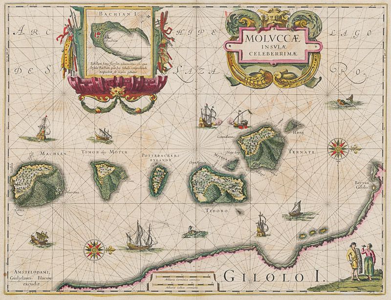
Border with longitudinal and latitudinal information. Beautifully detailed map of the Maluku Islands or the Moluccas in eastern Indonesia. The islands were known as the Spice Islands contain five islands of Volcanic origin (Ternate, Tidore, Moti, Makian and Bacan) and were highly prized for being the only source of nutmeg, cloves and mace. Islands identified on map are Machian, Timor/Motir, Pottebackers Eylandy, Tidoro, Miterra, Ternate and Haerij. Top section of map has inset box (8.8 cm x 9 cm) showing Bachan Island in greater detail. Inset shows fortification that the Dutch East India Company seized from the Spanish in 1609 and renamed Fort Barneveld. Inset box with ornamental cartouche decorated with weapons and navigation instrument on either side.
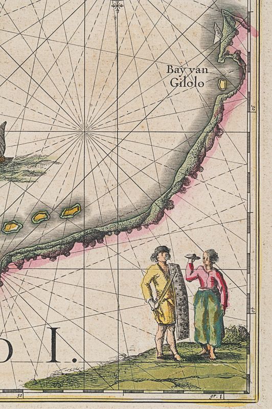
Decorative title cartouche in top section of map also. Gilolo Island (now known as Halmahera) shown in the lower corner of map. Two figures are shown in bottom left corner: one carrying shield and sword while the unarmed other is depicted with plate of offerings.
Naval ships and junks depicted throughout map. Exchange of naval artillery fire between European warship and junk shown near centre of map. Whale-like creature shown in top right of map. Map also shows fortifications on Machian and Ternate.
(Source: Digitial collection and information, ‘Strait Through: Magellan to Cook & the Pacific,’ available online from Princeton University website)
Willem Janszoon Blaeu (1571-1638) was a Dutch cartographer, atlas maker and publisher. Along with his son Johannes Blaeu, Willem is considered one of the notable figures of the Netherlandish/Dutch school of cartography in its golden age (the 16th and 17th centuries). Blaeu set up his mapmaking and publishing business in Amsterdam, where he sold instruments and globes, published maps, and edited the works of intellectuals like Descartes and Hugo Grotius. In 1633 he was appointed map-maker of the Dutch East India Company. In 1635, he released his atlas, Theatrum Orbis Terrarum, sive, Atlas novus.
Willem died in 1638. He had two sons, Cornelis (1610-1648) and Johannes (1596-1673). Joan trained as a lawyer, but joined his father’s business rather than practice. After his father’s death, the brothers took over their father’s shop and Joan took on his work as hydrographer to the Dutch East India Company. Later in life, Joan would modify and greatly expand his father’s Atlas novus, eventually releasing his masterpiece, the Atlas maior, between 1662 and 1672. (Wikipedia)
- Keywords: 17th Century · Aghada · Asia · Cartography · Catalogue No.5 – Maps of the World · Dutch · Dutch Colonialism/Imperialism · Dutch East Indian Company · Indonesia · Map · Original Engraving · Original Map · Original Maps · Rare Map Asia · Rare Map Southeast Asia · Spice Islands · Vintage Map
- Inventory Number: 200012AG
EUR 380,--
We ship per DHL Express


Contact
Inanna Rare Books Ltd.
Woodley House
Castletownshend Road
P81 D262 Skibbereen, County Cork
Ireland
Phone: ++353 - (0) 87 - 102 5412
E-Mail: info@inannararebooks.com
Internet: https://www.inannararebooks.com
Online Bookshop specialized in rare
and secondhand books.
Newsletter and E-Catalogue Sign Up
Payment Options


© 2024 Inanna Rare Books Ltd. | Powered by HESCOM-Software

