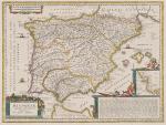
Goos, Hispaniae Veteris Descriptio.
Hispaniae Veteris Descriptio.
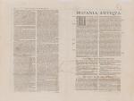
Original hand-coloured copper engraving. Amsterdam, Janssonius, [c.1662]. Plate Size: 49.2 cm x 37 cm. Sheet Size: 59.8 cm x 45 cm. Original map. Very good condition. Faint hint of foxing along left fore edge. Centre fold as issued. Latin text on reverse.
[Koeman I, 6000H:1.2].
Border with longitudinal and latitudinal information. A richly detailed and very interesting map showing Roman Hispania – the Iberian Peninsula and the Balearic Islands. The three Ancient Roman provinces (organised by the emperor Augustus) of Hispania Citerior et Tarraconensis, Hispania Baetica and Lusitania Hispania are shown on the map. Northern tip of Africa (‘Hispania Transfretana Sive Tingitana, Qua et Mauritania’) pictured also.
Relief shown pictorially with rivers, mountains and significant towns and cities depicted. Large decorative cartouche with finely detailed Classical allusions in lower right section of map contains an inset box showing the coastal area around ‘Gades’ (Cadiz). Cartouche also lists numerous place names of uncertain location (in Latin). Bar-scales within cartouche in top right corner of the map. Decorative title cartouche in lower left corner. Three ships are also pictured suggesting the region’s maritime importance. ‘Mare Mediterraneum Internum’ and ‘Ocean Atlanticus, Quod et Mare Hesperium, Vespertinum Occiduum, et Externum’ are also listed.
Abraham Goos (1590 – c. 1643) was a Dutch cartographer, publisher, and engraver. He made globes, maps of North America, a comprehensive map of European coastlines, and the first printed Hebrew language map of The Holy Land.
His first teacher was Jodocus Hondius (1563–1612), a renowned map-maker, whose son-in-law was Johannes Janssonius. After Hondius died, his son-in-law Jan Janssonius took over Hondius’s business and continued the partnership with Goos. One of Hondius’ specialties was the manufacture of globes, and Goos and Janssonius continued this, regularly modifying them as more geographical information became available. In 1616 he published Nieuw Nederlandtsch Caertboeck, an atlas of the Seventeen Provinces in 23 maps, and one of the first atlases of the Netherlands;
Johannes Janssonius (1588-1664) was a renowned geographer and publisher of the seventeenth century, when the Dutch dominated map publishing in Europe.
- Keywords: 17th Century · Ancient · Ancient Rome · Cartography · Catalogue No.5 – Maps of the World · Europe · Iberia · Latin · Map · Map, African · Mediterranean · Original Engraving · Original Map · Original Maps · Portugal · Rare Map Europe · Rare Map Portugal · Rare Map Spain · Spain · Vintage Map
- Inventory Number: 200014AG
EUR 650,--
© 2024 Inanna Rare Books Ltd. | Powered by HESCOM-Software


