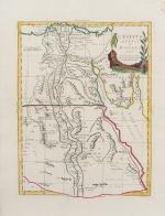
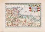
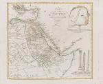
Inanna Rare Books

Inanna Rare Books

Inanna Rare Books

    • Home
    • About us
    • Shipping Information
    • Search File
    • Contact
    • Cart
    • Rare Book Room
      • Books on Books
      • History - Politics - Law
      • Literature
      • Philosophy & Religion
      • Social Sciences - Education
      • Medicine
      • The Arts
      • Travel & Exploration
      • Mathematics
      • Science & Technology
      • Farming - Fishing - Hunting
      • Natural History
      • Games - Sport
      • Complete Catalogue
    • Art & Map Gallery
      • Art Gallery
      • Rare Maps & Cartography
    • Manuscripts
      • Manuscripts - Literature
      • Manuscripts - History
      • Manuscripts - Travel
      • Manuscripts - Food
      • Manuscripts - Music
      • Manuscripts - Secret Knowledge
      • Manuscript Letters/Autographs
      • Manuscripts - Art
      • Manuscripts - Philosophy
    • Gift Ideas / New Arrivals
      • New Arrivals
      • Gift Ideas for Collectors
      • Gift Wrapping Available
      • Handmade Paper
      • Gift Wrapping Available
    • Inanna Publishing
    • Libraries & Collections
      • African Maps Collection
      • Henry David Aiken - Collection
      • Samuel Beckett - Collection
      • Walter Benjamin - Collection
      • Alexander Calder Collection
      • Castlefreke - Collection
      • Alice Curtayne Collection
      • Fly Fishing / Angling Collection
      • Vere Foster - Collection
      • William Daniel Gill Collection
      • John Minihan Collection
      • David (Dave) Naylor - Collection
      • Roger O'Connor Collection
      • David Puttnam Collection
      • Savigny Collection
      • Eric Ravilious Collection SOLD
    • Catalogues
    • News / Events
  • Advanced Search
  • List
    • Terms & Conditions
    • Return Policy
    • Privacy Policy
    • Shipping Information
    • Imprint
INANNA MODERNWest Cork Reading Holidays
We ship per DHL Express

We ship per DHL Express

Advanced Search
  • Rare Book Room
    • Books on Books
    • History - Politics - Law
    • Literature
    • Philosophy & Religion
    • Social Sciences - Education
    • Medicine
    • The Arts
    • Travel & Exploration
    • Mathematics
    • Science & Technology
    • Farming - Fishing - Hunting
    • Natural History
    • Games - Sport
    • Complete Catalogue
  • Art & Map Gallery
    • Art Gallery
    • Rare Maps & Cartography
  • Manuscripts
    • Manuscripts - Literature
    • Manuscripts - History
    • Manuscripts - Travel
    • Manuscripts - Food
    • Manuscripts - Music
    • Manuscripts - Secret Knowledge
    • Manuscript Letters/Autographs
    • Manuscripts - Art
    • Manuscripts - Philosophy
  • Gift Ideas / New Arrivals
    • New Arrivals
    • Gift Ideas for Collectors
    • Gift Wrapping Available
    • Handmade Paper
    • Gift Wrapping Available
  • Inanna Publishing
  • Libraries & Collections
    • African Maps Collection
    • Henry David Aiken - Collection
    • Samuel Beckett - Collection
    • Walter Benjamin - Collection
    • Alexander Calder Collection
    • Castlefreke - Collection
    • Alice Curtayne Collection
    • Fly Fishing / Angling Collection
    • Vere Foster - Collection
    • William Daniel Gill Collection
    • John Minihan Collection
    • David (Dave) Naylor - Collection
    • Roger O'Connor Collection
    • David Puttnam Collection
    • Savigny Collection
    • Eric Ravilious Collection SOLD
  • Catalogues
  • News / Events

Rare Maps – Africa (27 items)

Vaugondy, Karte von Egypten.

11. Egypt – Vaugondy, Robert. (1723 – 1786).

Karte von Egypten.

Original hand-coloured engraving. Augsburg, Joh. Walch, 1798. Plate Size: 54.5 cm x 49.2 cm. Sheet Size: 67.3 cm x 55.1 cm. Original map. In very good condition. Large margin between plate and sheet edges. Some spotting along sheet edges beyond map border. Central vertical fold as issued. Map is orientated to the north.

Show details

Zatta, L'Egitto Antico E Moderno.

12. Egypt – Zatta, Antonio. (1722 – 1804).

L’Egitto Antico E Moderno.

Original hand-coloured engraving. Venezia, Antonio Zatta E Figli, 1784. Plate Size: 31 cm x 40 cm. Sheet Size: 39 cm x 50.7 cm. Original map. Very good condition, with the slight traces of staining to lower section of map.

Show details

Zatta, La Guinea Occidentale.

13. Equatorial Guinea – Zatta, Antonio. (1722 – 1804).

La Guinea Occidentale.

Original hand-coloured engraving. Venezia, Antonio Zatta E Figli, 1784. Plate Size: 31 cm x 40 cm. Sheet Size: 51.7 cm x 38.8 cm. Original map. Very good condition. Map orientated to the north. Very minor foxing along top edge of sheet.

Show details

Zatta, Le Coste Di Barbaria

14. North Africa – Zatta, Antonio. (1722 – 1804).

Le Coste Di Barbaria Ovvero I Regni di Marocco di Fez di Algers di Tunisi di Tipoli coi Paesi Circonvicini.

Original hand-coloured engraving. Venezia, Antonio Zatta E Figli, 1784. Plate Size: 41.5 cm x 30.5 cm. Sheet Size: 50.6 cm x 38.8 cm. Original map with generous margins. Very good condition, with the only slightest traces of browning.

Show details

Lotter, Le Cours Entier du Grand et Fameux Nil.

15. Egypt – Lotter, Tobie Conrad. (1717 – 1777).

Le Cours Entier du Grand et Fameux Nil.

Original hand coloured engraving. Augsburg, Lotter, [c.1740]. Plate Size: 59.8 cm x 48.4 cm. Sheet Size: 65.4 cm x 53.6 cm. Original map. In very good condition. Partially coloured. Repaired tear to left edge of sheet. Minor tear to foot of sheet outside border. Central vertical fold as issued. Map is orientated to the north.

Show details

Tallis, Natal and Kaffraria (Eastern Cape of Africa) with Umzimvoobu

16. Tallis, John / Rapkin, John. (1817 – 1876)

Natal and Kaffraria (Eastern Cape of Africa) with Umzimvoobu, Ingali, Umbezana, Umzimkuli, Maritzburg, Durban, Umyoti, Drakenberg, Quathlamba or Drakenberg Range, Upper Tukula, Umzinyati, Zulu Country. With Vignettes and a beautiful, large illustration of the entrace to Port Natal and Port Natal and the town of Durban.

Original steel engraving / Vintage map. Drawn and engraved by John Rapkin. Partly hand-coloured. London & New York, J & F. Tallis, 1851. Beautifully Framed. Size of frame with map: 35 cm x 45 cm. Size of the actual map: 27 cm x 37 cm. Excellent condition.

Show details

Ortelius, Natoliae, quae olim Asia Minor Nova Descriptio

17. Mediterranean – Ortelius, Abraham. (1527 – 1598).

Natoliae, quae olim Asia Minor Nova Descriptio – Aegypti Recentior Descriptio – Carthaginis Celeberrimi Sinus Typus.

Original hand-coloured copper engraving. Antwerp, Ortelius, [c.1600]. Plate Size: 49 cm x 32.5 cm. Sheet Size: 53.8 cm x 36.2 cm. Original map. Very good condition. Clean and crisp. Reverse carries Latin text.

Show details

Tallis, Northern Africa with Algeria, Marocco and Tunis

18. Tallis, John / Rapkin, John. (1817 – 1876)

Northern Africa with Algeria, Marocco and Tunis and showing the Street of Gibraltar with southern Spain – with Vignettes and illustrations of Mogador / Marocco [Marokko] / Constantine [Constantinople / Istanbul] / Algiers / Tunis.

Original steel engraving / Vintage map. Drawn and engraved by John Rapkin. Partly hand-coloured. London & New York, J & F. Tallis, 1851. Beautifully Framed. Size of frame with map: 41.5 cm x 50.5 cm. Size of the actual map: 27 cm x 37 cm. Excellent condition.

Show details

Hand-coloured border with latitudinal and longitudinal lines. Coloured interior map borders. Very interesting and decorative map of the east coast of Africa (in modern-ay Mozambique), which was then u

19. East Africa – Zatta, Antonio. (1722 – 1804).

Parte Della Costa Orientale Dell’Africa con l’Isola dei Madagasear e le Carte particolari dell’Isole di Francia e di Borbon.

Original hand-coloured engraving. Venezia, Antonio Zatta E Figli, 1784. Plate Size: 40 cm x 30.5 cm. Sheet Size: 51 cm x 38.8 cm. Original map with good margins. Very good condition, with the only slightest traces of browning to outer margins.

Show details

Sanson d'Abbeville, Partie de Barbarie,

20. Tunisia / Libya – Sanson d’Abbeville, Nicolas. (1600 – 1667).

Partie de Barbarie, ou sont les Royaumes de Tunis, et Tripoli, Tires de Sanut et d’Autres.

Original hand-coloured engraving. Paris, Sanson d’Abbeville, [c.1658]. Plate Size: 28 cm x 18.2 cm. Sheet Size: 35.6 cm x 25 cm. Original map. In very good condition. With only the faintest signs of browning. Map orientated to the north.

Show details

Page: 1 2 3
:

Order by: Author · Title · Keyword · Year · Price (up) · Price (down) · Inventory Number · Recent Changes · Relevance

Books per page: 10 · 20 · 50 · 100

Contact

Inanna Rare Books Ltd.
Woodley House
Castletownshend Road
P81 D262 Skibbereen, County Cork
Ireland
Phone: ++353 - (0) 87 - 102 5412
E-Mail: info@inannararebooks.com
Internet: https://www.inannararebooks.com

Online Bookshop specialized in rare
and secondhand books.

Newsletter and E-Catalogue Sign Up

Enter your name and e-mail address to sign up for
our regular newsletter and catalogue service.

Payment Options

Paypal   Master Card   VISA   American Express

Legal Info

  • Terms & Conditions
  • Return Policy
  • Privacy Policy
  • Shipping Information
  • Imprint

© 2026 Inanna Rare Books Ltd. | Powered by HESCOM-Software