


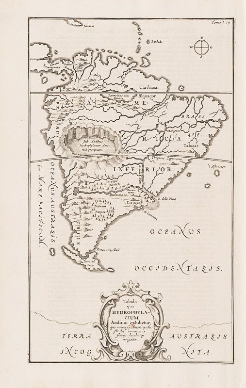
Kircher, Tabula qua Hydrophylacium Andium Exhibetur, quo Universa America Austra
Tabula qua Hydrophylacium Andium Exhibetur, quo Universa America Australis Innumeris Fluviis Lacubusque Irrigatur.
Original Engraving. Amsterdam, Kircher, [c.1665]. Plate Size: 20.1 cm x 33.9 cm. Sheet Size: 24.7 cm x 39 cm. Original Map. Very good condition. Very minor instance of foxing to cartouche. Map is orientated to the North. Dutch text on reverse.
A richly elaborate and highly imaginative map of South America (‘America Inferior’) from the Panama Isthmus in the north to Terra del Fuego in the south. The south part of Jamaica and Barbados are shown near the top of the map. Ascension Island is also shown off the coast. The continent appears bulging and does not bear the more elongated form of later maps.
River, lake, forest, mountain and volcano features are engraved on the map: the Amazon river, Andes mountains and Lake Titicacca (‘Parime lacus, alias Titicacca’) are all shown. The settlements of Darien, Carragocaro, and ‘Buenos ayros’ are identified. ‘Peru’, ‘Chile’ and ‘Paraquay’ all appear on the map, but political details – such as borders – are absent. An unknown and imagined ‘Terra Austrasis Incognita’ lies at the bottom of the map. Decorative title cartouche at the lower section of the map. However, the map stands out for the craterous lake depicted at the centre of the map, between the Equator and the Tropic of Capricorn. It is captioned as ‘Sub Andibus Hydrophylacium America precipuum’.
This is one of several maps prepared by Kircher to illustrate his unique hydro-geographic theory. Kircher hypothesized that tides and currents are caused by water moving to and from a massive subterranean ocean. Kircher further postulated that water entered and exited the subterranean ocean via a number of great abysses situated around the globe. In addition, he believed that massive underground lakes lay beneath most of the world’s great mountain ranges. The map appeared in Kircher’s book, Mundus Subterraneus (The Subterranean World) that was first published in 1665 laying out his (pseudo-) scientific theories on hydro-geology.
Athanasius Kircher, (1602 – 1680) was a German Jesuit scholar and polymath who published around 40 major works, most notably in the fields of comparative religion, geology, and medicine. Kircher has been compared to fellow Jesuit Roger Boscovich and to Leonardo da Vinci for his enormous range of interests, and has been honoured with the title “Master of a Hundred Arts”. A refugee from the war-torn German territories, he taught for more than forty years at the Roman College, where he set up a museum-type cabinet of curiosities or wunderkammer. A resurgence of interest in Kircher has occurred within the scholarly community in recent decades. A scientific star in his day, towards the end of his life he was eclipsed by the rationalism of René Descartes and others. In the late 20th century, however, the aesthetic qualities of his work again began to be appreciated. One modern scholar, Alan Cutler, described Kircher as “a giant among seventeenth-century scholars”, and “one of the last thinkers who could rightfully claim all knowledge as his domain”. Another scholar, Edward W. Schmidt, referred to Kircher as “the last Renaissance man”. (Wikipedia)
- Keywords: 17th Century · Amazon · Cartography · Catalogue No.5 – Maps of the World · Chile · Hydrology · Map · Maps of the Americas and Caribbean · Original Engraving · Original Map · Original Maps · Paraguay · Peru · Rare Map South America · Rare Map The Americas · Rivers · South America · South America Maps · Vintage Map
- Inventory Number: 200011AG
EUR 360,--
We ship per DHL Express


Contact
Inanna Rare Books Ltd.
Woodley House
Castletownshend Road
P81 D262 Skibbereen, County Cork
Ireland
Phone: ++353 - (0) 87 - 102 5412
E-Mail: info@inannararebooks.com
Internet: https://www.inannararebooks.com
Online Bookshop specialized in rare
and secondhand books.
Newsletter and E-Catalogue Sign Up
Payment Options


© 2026 Inanna Rare Books Ltd. | Powered by HESCOM-Software
Follow Us

