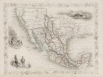
Mexico, California and Texas with Vignettes and illustrations of the Ruins at Uxmal on the Yucatan Peninsula, Mexican Peasantry, Gold Washing. Showing also the gold districts of California which subsequently led to the Gold Rush.
Original steel engraving / Vintage map. Drawn and engraved by John Rapkin. Partly hand-coloured. London & New York, J & F. Tallis, 1851. Plate Size: 33 cm x 25 cm. Sheet Size: 37.6 cm x 27.3 cm. Vintage 19th century map in very good condition.
EUR 350,--





![Tallis, Venezuela, New Granada, Equador [Ecuador] and the Guayanas](/images/thumbnails/2008AG.jpg)
![Tallis, United States [of America]](/images/thumbnails/2012AG.jpg)


